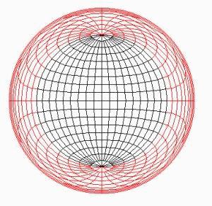
EQUAL AREA OR SCHMIDT NET
As the name implies, this projection conserves area. Shapes are not preserved but shape distortion is not too bad in the near hemisphere.
In principle the entire sphere can be plotted but in practice shape distortion beyond 90 degrees becomes high and beyond 135 degrees is so severe tobe practically useless. Meridians and parallels are complex curves (fourth order quadrics). Because area is conserved, this is the projection of choice for statistical comparison of spatial data and has much application in structural geology. Looking along the zenith, the projection is oriented with north up along the y axis and east along the x axis. Coordinates are represented in terms of latitude (l) and longitude (w), with the projection centered on latitude 0, longitude 0.
If x, y, and z be the coordinates of points on the sphere and X and Y the coordinates of the same point on the projection plane, the origin is at the center of the sphere and the radius of the sphere is 1. Thus the north pole is at (0,1,0) and the south pole is at (0, -1, 0). The point of tangency is at (0,0,1). The projection plane is z = 1.
The coordinates of a point at (l, w) are:
x = cos l sin w
y = sin l
z = cos l cos w
Because the sphere is a unit sphere, x2 + y2 + z2 = 1.
It is also useful to note that
x2 + y2 =1 - z2.
Because all the projections are azimuthal, the azimuth of the projected point from (X = 0,Y = 0) is always the same as the azimuth on the sphere from (l = 0, w = 0). The azimuth is most simply represented as arctan (y/x), but x/y is infinite if x = 0 and arctan A =arctan(180 + A). The ambiguity can be removed by noting that tan A/2 = sin A/(1 + cos A). Defining r = sqrt(x2 + y2), the radial distance of the point on the sphere from the z axis, sin A = y/r and cos A = x/r and thus tan A/2 = (y/r)/(1+x/r), or tan A/2 = y/(r+x).
Hence, A = 2arctan(y/(r+x)).